Highlights
Land Use, Hydrology, and Climate Influence Water Quality of China’s Largest River
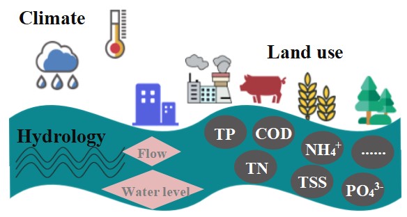
Land use, hydrology, and climate influence water quality of China’s largest river (Image by IHB)
It is critical to understand the relationship between landscape patterns shaped by human activities and the aquatic ecosystem in order to develop strategies and plans for conserving aquatic biodiversity and ecosystem health. However, the majority of this type of study has been conducted in small wadable rivers and streams or specific river reaches of large rivers. Few large-scale landscape-related studies have been reported for large nonwadable rivers such as the Yangtze River, especially when considering multiple factors including land use, hydrology and climate.
The research team led by Prof. CHEN Yushun from the Institute of Hydrobiology (IHB) of the Chinese Academy of Sciences, in collaboration with the China Institute of Water Resources and Hydropower Research, Chinese Academy of Environmental Planning, and China Three Gorges Corporation, have found that water quality spatial patterns were mainly driven by heterogeneity in land use (i.e., wetland, cropland, and urban land), hydrology (i.e., water flow, water level), and climate (i.e., rainfall, air temperature). The results were recently published in Journal of Environmental Management.
In this study, the researchers measured a total of 15 types of water quality parameters, including total phosphorus (TP), total nitrogen (TN), and chemical oxygen demand (COD), and collected driving factors data, including land use, hydrology, and climate factors.
To detect spatial and seasonal water quality patterns in the middle and lower Yangtze River, the researchers conducted one-way permutational multivariate analysis of variance (one-way PERMANOVA) and principal components analysis (PCA). Results showed that compared with the dry season, the wet season had significantly higher TP, COD, total suspended solids (TSS), and turbidity (TUR). The water quality index (WQI) indicated “Moderate” and “Good” water quality in the wet and dry seasons, respectively. Compared with other sites, the upper reach sites that right downstream the Three Gorges Dam had lower TP, TN, TSS and TUR in both seasons, and had lower and higher water temperature in the wet and dry seasons, respectively.
In addition, the researchers quantified the influences of land use, hydrology, and climate factors on spatial patterns of water quality in wet and dry seasons by using a variance partitioning analysis. They found that water quality in the wet season was primarily driven by land use while the joint effect of land use and hydrology dominated in the dry season.
In the wet season, the effect of the land use factors (22%) was the largest, followed by the hydrology effect (14%) and land use-hydrology-climate joint effect (2%). In the dry season, the joint effect of the land use and hydrology factors had the highest influence on water quality, followed by the effect of hydrology (10%), climate (9%), and land use (4%) factors.
This study shows that human stressors within the 5km riparian buffer zone of the mainstem Yangtze River is critical in affecting both fish communities and water quality. Decision-makers and regulators of large river basin management may need to develop programs that consider influences from both human and natural drivers for water quality conservation.
The finding has important implications in the ecological protection and management of the Yangtze River, and can provide significant references for the protection of large rivers elsewhere.
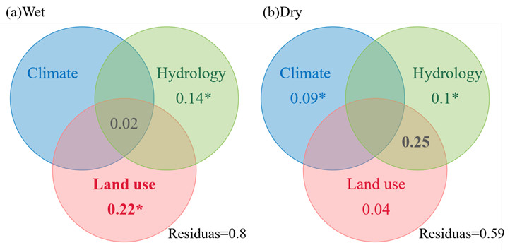
Venn diagrams illustrating results of variation partitioning of different driving factors in explaining water quality for the (a) wet and (b) dry seasons in the middle and lower Yangtze River during 2017-2018. (Image by IHB)
(Editor: MA Yun)